 FLASH SALE: EVERYTHING HALF PRICE! LIMITED TIME ONLY!
 Sale!
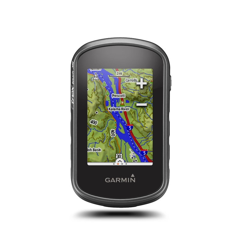
Sale! Garmin eTrex Touch 35t GPS & GLONASS Handheld
- $349.99
- $98.00
eTrex Touch 35t is a compact, rugged and reliable GPS/GLONASS handheld with color touchscreen, preloaded TOPO 100K maps, dual GPS and GLONASS satellites positioning, 250,000 preloaded geocaches and wireless connectivity (ANT+, VIRB and smart notifications)
- 100% Happiness Backed or Your Money Back
- Free Delivery on 30+ Orders
- 60-Day Hassle-Free Returns
eTrex Touch 35t is a compact, rugged and reliable GPS/GLONASS handheld with color touchscreen, preloaded TOPO 100K maps, dual GPS and GLONASS satellites positioning, 250,000 preloaded geocaches and wireless connectivity (ANT+, VIRB and smart notifications). With a 3-axis tilt-compensated electronic compass and barometric altimeter, youre ready to navigate anywhere.
- Physical dimensions 2.3 x 4.0 x 1.3 (5.8 x 10.2 x 3.3 cm)
- Display size, WxH 1.43″ x 2.15″ (3.6 x 5.5 cm)
- Display resolution, WxH 160 x 240 pixels
- Display type 2.6″ 65K color TFT
- Touchscreen
- Weight 5.6 oz (159 g) with batteries
- Battery 2 AA batteries (not included); NiMH or Lithium recommended
- Battery life Up to 16 hours
- Water rating IPX7
- High-sensitivity receiver
- Interface USB
- Barometric altimeter
- Electronic compass
- Unit-to-unit transfer (shares data wirelessly with similar units)
- Maps & Memory
- Basemap
- Preloaded maps yes (topographic)
- Built-in memory 8GB
- Accepts data cards microSD card (not included)
- Custom POIs (ability to add additional points of interest)
- Waypoints/favorites/locations 4000
- Routes 200
- Track log 10,000 points, 200 saved tracks
- Automatic routing (turn by turn routing on roads) Yes (with optional mapping for detailed roads)
- Geocaching-friendly Yes (Paperless)
- Custom maps compatible
- Sun and moon information
- Tide tables Yes (with optional Bluechart)
- Area calculation
- Picture viewer
- Garmin Connect
- Garmin Connect compatible (online community where you analyze, categorize and share data)
- Smart Notifications: yes
- Live Tracking: yes (with Garmin Connect Mobile)
- 2.6-inch color capacitive touchscreen
- 3-axis tilt-compensated compass and barometric altimeter
- GPS and GLONASS satellites for faster positioning
- 250,000 preloaded geocaches from Geocaching.com
- Preloaded TOPO U.S. 100K maps with extra internal memory to hold more maps
Cost:
$25
Free Shipping:
We offer free shipping on orders over $30. Please check the free - shipping eligibility at checkout.
Delivery Time:
It usually takes [3-5] business days for standard shipping. Please note that this is an estimated time frame and may be affected by local holidays, and unforeseen circumstances.

Reviews
There are no reviews yet.